Global estimates of ground surface temperature from borehole inversions
This dataset includes global estimates of ground surface temperature for the period 1465-2000 C.E. The time series were created using the profiles available in the Xibalbà dataset and three different methods to estimate the global averages and uncertainties. The values were retrieved and analyzed with the CIBOR software.
The datasets in this repository were created by applying three different methods to estimate global means and uncertainties:
The results of a typical Singular Value Decomposition (SVD) analysis based on Beltrami et al. (1992) are provided in the file `singular_value_decomposition.csv`.
The results of a perturbed parameter analysis of the thermal properties of the ground are provided in the file `perturbed_parameter_ensemble.csv`.
The results of a bootstraping estimate from a Monte-Carlo ensemble of inversions are provided in the file `bootstrapping.csv`.
IMPORTANT: we recommend using the results of the file `bootstrapping.csv`. The other two files are provided for comparison purposes, but the results of the bootstraping technique are more robust.
All inversions were performed retaining the two largest eigenvalues in the SVD algorithm and considering a step change of 30 years in the retrieved surface signal. Inversions in the `singular_value_decomposition.csv` file consider a constant thermal diffusivity of \(\mathrm{1.0\times 10^{-6}\ m^{2}\, s^{-1}}\), while the other two files consider a range of diffusivities between \(\mathrm{0.5\times 10^{-6}}\) and \(\mathrm{1.5\times 10^{-6}\ m^{2}\, s^{-1}}\). The `perturbed_parameter_ensemble.csv` file considers an ensemble of 100 members, while the `bootstrapping.csv` file considers a Monte-Carlo ensemble of 1000 members.
Reference:
Cuesta-Valero, F. J., Beltrami, H., Gruber, S., García-García, A., and González-Rouco, J. F. (2022). A new bootstrap technique to quantify uncertainty in estimates of ground surface temperature and ground heat flux histories from geothermal data. Geosci. Model Dev., 15, 7913-7932, doi:10.5194/gmd-15-7913-2022.
Code:
Cuesta-Valero, F. J. (2022). CIBOR: Codes for Inverting BOReholes (Version 1.0.0). [Computer software]. https://doi.org/10.5281/zenodo.7017521.
Data:
Cuesta-Valero, F. J. (2026). A new bootstrap technique to quantify uncertainty in estimates of ground surface temperature and ground heat flux histories from geothermal data: global borehole inversions. [Data set]. Zenodo. https://doi.org/10.5281/zenodo.18547905.
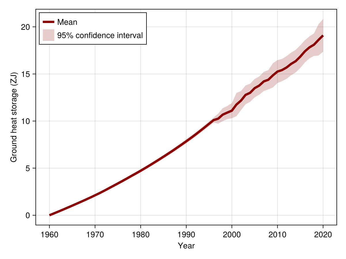
Ground heat storage from satellite and geothermal data
This dataset provides unified estimates of Global Ground Heat Storage (GHS) since 1960 by combining low-frequency geothermal measurements with annual-resolution satellite products. This unique combination spans the period 1960-2020, effectively bridging the data gap that previously existed in geothermal records after the year 2000.
The geothermal GHS estimates are the same as those published in Cuesta-Valero et al. (2022). These values were derived from the inversion of 1079 subsurface temperature profiles taken from the Xibalbà database. The satellite GHS estimates were retrieved using land surface temperatures and land cover type data provided by the ESA-CCI project, and the retrieval process also incorporated data from the ERA5-Land reanalysis.
Due to the inherent difference in temporal resolution and reference period between the geothermal and satellite data sources, two distinct methods were employed to reconcile the estimates:
The final dataset includes the GHS derived from both reconciliation methods, alongside a single combined average of the two estimates.
Reference:
Cuesta-Valero, F. J., García-García, A., Beltrami, H., Garcí-Pereira, F., González-Rouco, J. F., and Peng, J.(2025). Robust increase in observed heat storage by the global subsurface. Science Advances, https://doi.org/10.1126/sciadv.adw9958.
Data:
Cuesta-Valero, F. J. (2025). Robust increase in observed heat storage by the global subsurface: Ground heat storage estimates (1.0.0) [Data set]. Zenodo. https://doi.org/10.5281/zenodo.17339736.
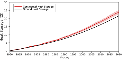
Continental Heat Storage and Ground Heat Storage
This dataset contains an updated estimate of the global continental heat storage for the period 1960-2020. For the first time, the continental heat storage is assessed as composed by: ground heat storage due to changes in subsurface temperatures, inland water heat storage due to the warming of inland water bodies, and permafrost heat storage due to thawing of ground ice in the Arctic.
Additionally, the dataset includes the global ground heat storage for the period 1960-2020. The ground heat storage has been estimated by inverting 1079 subsurface temperature profiles form the Xibalbá database (see below in this webpage) and a bootstrap technique to aggregate the Singular Value Decomposition (SVD) inversions of each profile (see the Research section in this webpage).
Currently, the dataset is in its second version, which includes an update of continental heat content uncertainty, where the standard deviation has been corrected from the precedent version to consider properly the value from permafrost heat storage uncertainty.
Reference:
von Schuckmann, K., Minière, A., Gues, F., Cuesta-Valero, F. J., Kirchengast, G., Adusumilli, S., Straneo, F., Ablain, M., Allan, R. P., Barker, P. M., Beltrami, H., Blazquez, A., Boyer, T., Cheng, L., Church, J., Desbruyeres, D., Dolman, H., Domingues, C. M., García-García, A., Giglio, D., Gilson, J. E., Gorfer, M., Haimberger, L., Hakuba, M. Z., Hendricks, S., Hosoda, S., Johnson, G. C., Killick, R., King, B., Kolodziejczyk, N., Korosov, A., Krinner, G., Kuusela, M., Landerer, F. W., Langer, M., Lavergne, T., Lawrence, I., Li, Y., Lyman, J., Marti, F., Marzeion, B., Mayer, M., MacDougall, A. H., McDougall, T., Monselesan, D. P., Nitzbon, J., Otosaka, I., Peng, J., Purkey, S., Roemmich, D., Sato, K., Sato, K., Savita, A., Schweiger, A., Shepherd, A., Seneviratne, S. I., Simons, L., Slater, D. A., Slater, T., Steiner, A. K., Suga, T., Szekely, T., Thiery, W., Timmermans, M.-L., Vanderkelen, I., Wjiffels, S. E., Wu, T., and Zemp, M. (2023). Heat stored in the Earth system 1960-2020: where does the energy go? Earth Syst. Sci. Data, 15, 1675-1709, https://doi.org/10.5194/essd-15-1675-2023.
Data:
Cuesta-Valero, F.J., Beltrami, H., García-García, A., Krinner, G., Langer, M., MacDougall, A., Nitzbon, J, Peng, J., von Schuckmann, K., Seneviratne, S.I., Thiery, W., Vanderkelen, I., Wu, T. (2023). GCOS EHI 1960-2020 Continental Heat Content (Version 2). World Data Center for Climate (WDCC) at DKRZ. https://doi.org/10.26050/WDCC/GCOS_EHI_1960-2020_CoHC_v2.
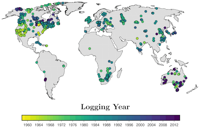
Xibalbá Profiles
Dataset containing 1079 subsurface temperature-depth profiles measured around the world. Each log has been screened to eliminate those containing non-climatic artifacts. The subsurface temperature logs comprising this database are the result of the quality-control process explained in Cuesta-Valero et al. (2021), including the following harmonization requeriments:
Each log include at least one temperature record between 15 m and 100 m of depth.
Each log include at least one temperature record between 250 m and 310 m of depth.
Each log include at least three temperature records between 200 m and 300 m of depth.
All boreholes are truncated to include temperature records between 15 m and 300 m of depth.
Reference:
Cuesta-Valero F.J., García-García A., Beltrami H., González-Rouco J.F., and García-Bustamante E. (2021). Long-Term Global Ground Heat Flux and Continental Heat Storage from Geothermal Data. Clim. Past, 17, 451-468, doi:10.5194/cp-17-451-2021. Article highlighted by the editors of CP.
Data:
Cuesta-Valero, F.J., Beltrami, H., García-García, A., González-Rouco, J. F., García-Bustamante, E. (2021). Xibalbá: Underground Temperature Database. figshare. Dataset. https://doi.org/10.6084/m9.figshare.13516487.v4.
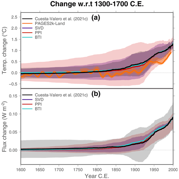
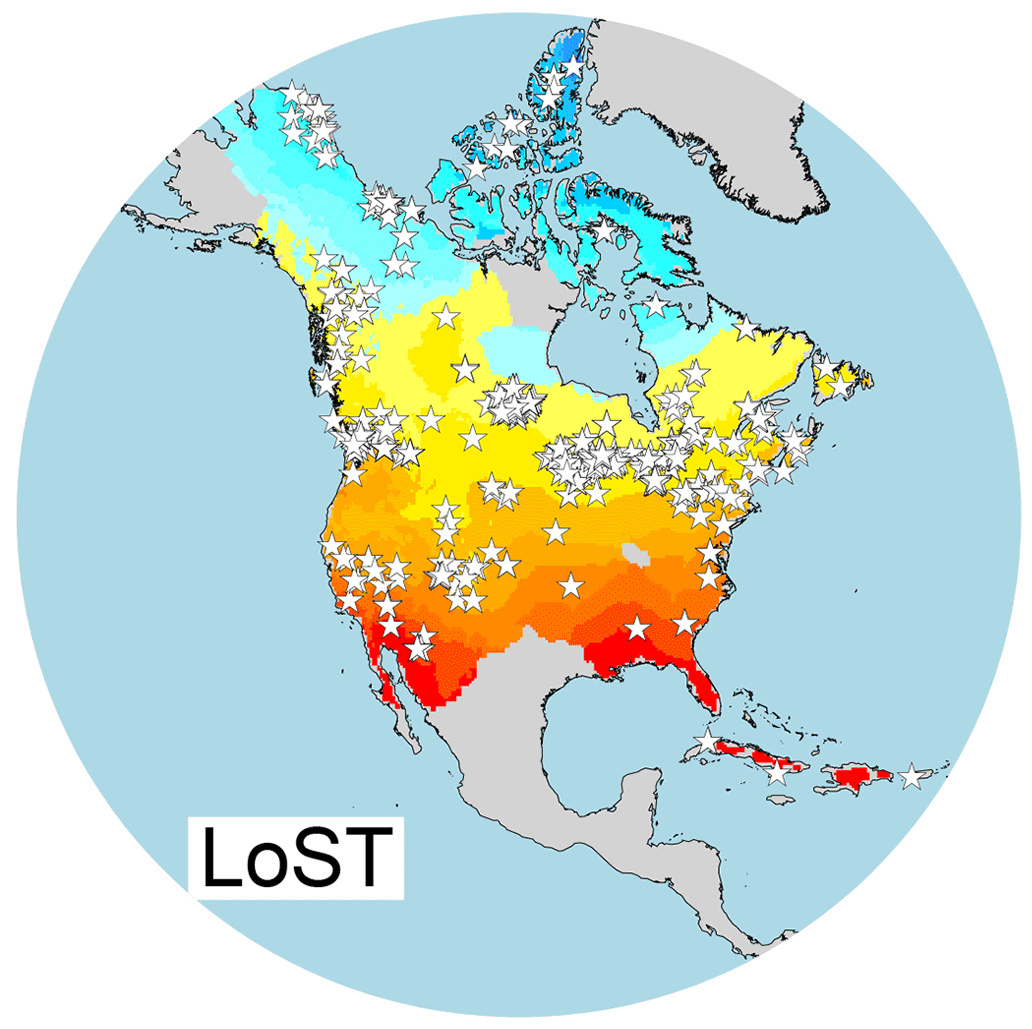
Long-term Surface Temperature (LoST) Database
Dataset containing long-term surface absolute temperatures for the period ~1300-1700 of the Comon Era (CE) over North America and some Caribbean islands. Long-term climatology estimates from 514 subsurface temperature profiles are retrieved and interpolated into a NetCDF file in order to facilitate its use and distribution.
All subsurface temperature-depth profiles were truncated to the depth range between 199 m and 300 m in order to retrieve estimates for the same temporal period according to the equation
$$
t \propto \frac{z^{2}}{4\cdot \kappa}
$$
where \(t\) is time since the surface signal happend, \(z\) is depth at which the signature of the surface perturbation is recorded, and \(\kappa\) is the thermal diffusivity of the ground.
A Gradient plus Inverse Distance Squared (GIDS) interpolation to a \(0.5^{\circ}\times 0.5^{\circ}\) grid was performed considering all 514 estimates from subsurface temperature profiles. Only grid cells within a radious of 650 km around a subsurface temperature profile were considered. This distance criterium was obtained from a pseudo-proxy experiment using five CMIP5 Past Millennium simulations, and consist in the maximum distance in which the RMSE between interpolated temperatures and the entire distribution of simulated temperatures in North America is smaller than \(1\ ^{\circ}C\) for all five models. Please, see the reference for more details.
Reference:
Cuesta-Valero F.J., García-García A., Beltrami H., Zorita E. and Jaume-Santero F. (2019). Long-term Surface Temperature (LoST) database as a complement for GCM preindustrial simulations. Climate of the Past, 15, 1099-1111, doi:10.5194/cp-15-1099-2019.
Data:
Cuesta-Valero, F. J., García-García, A., Beltrami, H., Zorita, E., Jaume-Santero, F. (2019). Long-term Surface Temperature (LoST) Database. figshare. Dataset. https://doi.org/10.6084/m9.figshare.8124887.v1.